Projections
Projection types
When it comes to presenting maps to readers, geographers must choose a projection that is appropriate for the map's purpose and location. Projections transform three-dimensional curved surfaces to two-dimensional flat surfaces. Consequently, such transformations cause distortion to the maps. The following are the 4 types in which the relationship between features on a map may be distorted or preserved:
- Distance (Equidistant)
- Preserves distance between features
- True Direction (Azimuth)
- Preserves direction between features
- Measured in degrees (°)
- Shape / Angle (Conformal)
- Cannot preserve shape and area at the same time
- Continents distorted
- Area (Equal-Area)
- Distorts distance and shape
- Preserves features to their exact size
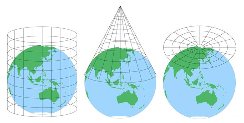
Projection techniques
The projection techniques, which affect the longitude (vertical lines) and latitude (horizontal lines) on a map, are another significant factor to consider. The following are the 3 primary projection techniques:
- Cylindrical
- Longitude lines appear straight, equally spaced, and parallel
- Latitude lines appear straight, and sometimes not consistently equally spaced
- Conical
- Longitude lines appear as diverging
- Latitude lines appear circular around the poles
- Azimuthal (or Planar)
- Increasingly distorted from the centre point (typically the South or North Pole as the centre point)
- Longitude lines appear equally spaced and straight which become increasingly radiant
- Latitude lines appear as equally spaced centric circles
Coordinate Reference Systems
Working with any spatial data requires knowledge of Coordinate Reference Systems (CRS) and projections. A CRS defines how coordinate values in your GIS relate to real places on the earth.
A CRS may be geographic (ellipsoid latitude/longitude) or projected (2D plane). Every geodetic (latitude/longitude) CRS is based on a datum, a mathematical model of Earth's shape, such as WGS 84 or NAD 83.
If two layers, like points, lines, polygons, and rasters use different CRS, they may not line up correctly on the map, negatively affecting any spatial analysis you perform such as measuring distances, creating buffers, or performing spatial joins.
Any GIS workflow should start with double-checking your data's CRS and projection information. Different parts of the world may have their own preferred CRS for local accuracy. It's all part of the challenge of turning the earth into a flat map.
EPSG codes are used to identify CRS (both geographic and projected), such as EPSG:4326 for WGS 84 geographic and EPSG:3857 for Web/Pseudo Mercator, which is used by Google Maps. You can search for them at epsg.io.
Projection explorer
Try out the projection explorer below now that you've learned about projection types and techniques.
Test your knowledge
The Albers projection uses which technique and type?